Civil Engineering Consultants
9 AM to 7 PM Monday-Saturday
Ph: +91-9571483735 (sales)
+91-9571483735 (Sales)
Email: sales@geovate.co.in (Sales)
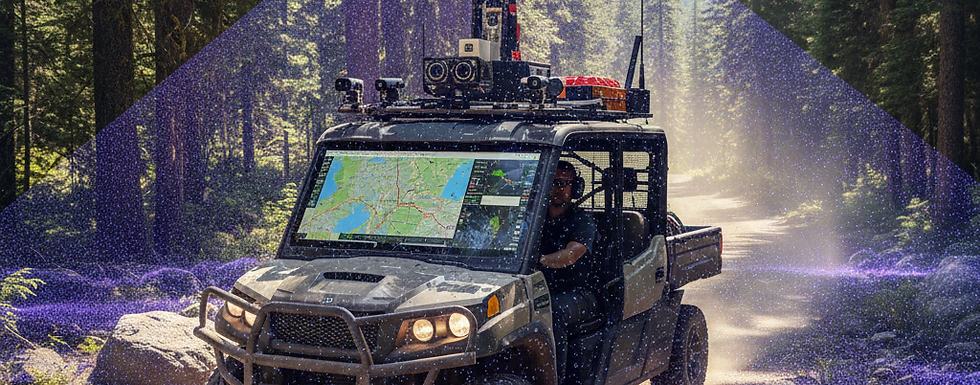
Best Price Mobile Lidar Mapping Company in Delhi Vehicle-mounted,Backpack,Boat-mounted,Hybrid
Mobile LiDAR mapping has revolutionized transportation infrastructure management by enabling rapid, high-accuracy data collection along highways, railways, and urban roadways. Vehicle-mounted systems capture dense point clouds at traffic speeds, facilitating detailed roadway asset inventories—including signs, guardrails, pavement conditions, curbs, and lane markings—while minimizing traffic disruptions and enhancing worker safety. This technology supports pavement analysis for detecting rutting, cracks, and settlement, as well as clearance measurements under bridges and overpasses. In design and maintenance phases, engineers use the data for geometric assessments, drainage modeling, and change detection between as-built and design surfaces. With trends toward AI-driven classification and real-time processing in 2025–2026, mobile LiDAR streamlines corridor mapping for large-scale projects, improves asset management efficiency, and aids in predictive maintenance, ultimately reducing costs and supporting sustainable transportation networks.
In urban planning and smart city development, mobile LiDAR mapping provides comprehensive 3D geospatial data essential for creating accurate city models and supporting informed decision-making. By scanning streetscapes, buildings, vegetation, and utilities from vehicles or portable platforms, it generates detailed point clouds that reveal vertical structures, road networks, and environmental features often missed by traditional methods. Planners utilize this information for zoning, traffic flow simulations, green space optimization, and flood risk assessment. Integration with GIS and digital twin technologies allows virtual testing of infrastructure changes, such as new bike lanes or public transit routes, to evaluate impacts on safety, accessibility, and sustainability. Emerging 2026 trends emphasize multi-sensor fusion with imagery and AI for semantic segmentation, enabling dynamic urban modeling that adapts to real-time changes and promotes resilient, efficient city growth.
Utilities and power infrastructure benefit immensely from mobile LiDAR mapping through precise corridor scanning of transmission lines, pipelines, poles, and substations. Vehicle- or rail-mounted systems efficiently map overhead wires, vegetation encroachment, and structural elements along extensive routes, supporting asset inventory, risk assessment, and preventive maintenance. The technology detects clearance violations, tower deformations, and tilt in real time, crucial for avoiding outages and ensuring regulatory compliance. In renewable energy sectors, it aids in siting solar farms or wind corridors by providing accurate terrain and obstacle data. With advancements in real-time SLAM for GNSS-denied areas like tunnels or dense forests, and AI-powered point cloud processing for automated feature extraction, mobile LiDAR enhances operational efficiency, reduces fieldwork hazards, and enables predictive analytics for infrastructure longevity in utilities management.
Best Price Mobile Lidar Mapping Company in Delhi Vehicle-mounted,Backpack,Boat-mounted,Hybrid
Best Price Mobile Lidar Mapping Company in Delhi, NCR | Geovate
Best Price Mobile Lidar Mapping Company in Delhi, NCR.|Vehicle-mounted,Backpack,Boat-mounted,Hybrid
The rise of autonomous vehicles (AVs) and advanced driver-assistance systems (ADAS) relies heavily on mobile LiDAR mapping to create high-definition (HD) maps and support safe navigation. Repeated scans of roadways produce detailed 3D representations of lanes, curbs, signs, pedestrians, and dynamic elements, essential for localization, obstacle detection, and path planning in complex urban environments. These maps enable precise vehicle positioning even in challenging conditions, bridging gaps in GNSS coverage. As AV adoption accelerates in 2025–2026, trends focus on real-time mapping updates, multi-sensor integration, and scalable data collection from fleets. Mobile LiDAR contributes to safer mobility by facilitating simulation testing, regulatory compliance, and continuous map refinement, ultimately accelerating the deployment of reliable autonomous transportation systems worldwide.
Beyond core sectors, mobile LiDAR mapping finds versatile applications in construction, environmental monitoring, and digital twin creation across industries. In construction, it supports pre-project surveys, quantity estimations, progress tracking, and as-built verification through high-density point clouds for BIM integration. Environmental uses include vegetation inventory, habitat mapping, and coastal or flood zone analysis. The push toward digital twins—virtual replicas of physical assets—leverages mobile LiDAR data for immersive simulations, predictive maintenance, and scenario planning in smart infrastructure. 2026 trends highlight AI automation, solid-state sensors, and hybrid platforms (vehicle + portable) for faster, more accessible data capture. This technology bridges traditional surveying with modern geospatial demands, driving efficiency, sustainability, and innovation in diverse fields like mining, forestry, and disaster response.
